")
From the book "Straight to the South", part 1 "Expedition to the heart of Sri Lanka", episode 3.
| 08.03.2018 | 7°56'30.35"N 80°59'54.23"E – ticket office and entrance to the archaeological museum |
A trip to the medieval town of Polonnaruwa - the second oldest capital of the Lankan kings, where they ruled from 1070 to 1293 years. Until this time, from the middle of the I century BC, the administrative capital of the island was the city of Anuradhapura, which we could not visit because the day before there were religious riots there, and the government temporarily restricted visiting its surroundings.
We drove with stops: souvenir shops, beggars-monkeys on roadsides.. Well, of cause we threw bananas for those pretty little guys!
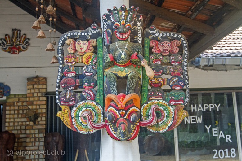
Wooden carved bas-relief at the entrance to the souvenir shop
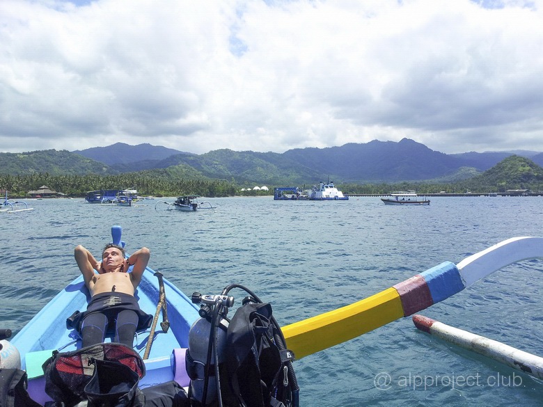
From the book "Straight to the South", part 1 "Expedition to the heart of Sri Lanka", episode 2.
| 07 and 09.03.2018 | 7°57'55.62"N 80°45'42.82"E |
We had only three full days in Sri Lanka. It is quite a bit and we did not drive to the sea and decided to spend them in the Central province, near the city of Dambulla. Local places are steeped in history. Enough to say that ancient inhabitants of the island belonged to the Veddo-Australoid race, bringing together representatives of the Australian and Veddoid or Ceylon-Sunda lesser races. Scientists believe that these peoples were the first human group who leaved Africa (the ancestral home of mankind) in the stone age and settled part of South and South-East Asia and the Eastern part of the tropical belt of the Old World, from Hindustan to Indochina and the Malay archipelago, and even to Australia. At the same time, they are genetically isolated from Europeoids and Mongoloids and do not have common ancestors with Negroids, some resemblance to the Negroids can only be explained by living in similar climate conditions. And then people who settled the island of Sri Lanka had a lot of interesting ...
Small family hotel Sigiri Rock Side Home Stay (7°56'57.67"N 80°45'17.89"E, that in the vicinity of the ancient city of Sigiriya) was clean and cozy. The Breakfast room cost for us about USD 35 per night. In the mornings we were woken up by wild monkeys jumping on a roof, the hospitable hostess treated us with freshly prepared dishes - pancakes and cakes of roti with tasty sauces, scrambled eggs, fresh fruits and the owner, the archaeologist and the local historian, helped us to organize hikes on vicinities .
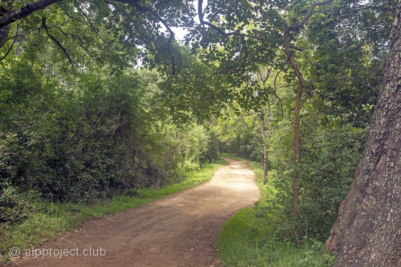
The road to our hotel
From the book "Straight to the South", part 1 "Expedition to the heart of Sri Lanka", episode 1.
06.03.2018
Rare case, we are going to fly from our native airport Manas and even at a convenient time at 9:00 am. Flight Bishkek - Delhi by Air Manas plane, ticket costs 149 USD, time in flight about 3 hours. Let's fly!
the Tien Shan fnd Pamir mountains are hidden by clouds, the mountains started to be visible only after an hour and a half later, when Afghanistan was under us. It was a Hindu Kush mountains, then foothills of the Himalayas and far away rising to the sky - main ridge with its giant peaks. The sky is just a background for Nanga Parbat peak (8125 m), further it could be seen Gasherbrum I (8080 m) and the northernmost and second highest of the world's giants - Chogori or K-2 (8661 m), ascent to which is fatal for every fourth climber..
Then the mountains under us were replaced by a minorhills, then it gone and the plain of continental India began - scattered among green fields settlements-stars, rivers and canals, threads of roads..
Building density increased closer to Delhi and here you are the metropolis is under us, where among the poor areas of old buildings, as high bushes among the grass, modern high-rise buildings have grown and wide highways lay straight..
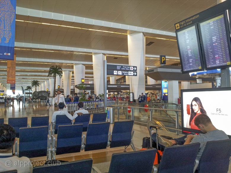
Indira Gandhi airport, Terminal 3, New Delhi
| February 4, 2018 | 42°38'21.36"N 74°38'18.08"E |
Often our friends from different countries ask us: 'Can you go skiing in your country?' It is possible! There are several ski bases around the capital, there is a high-altitude base on the pass to the Suusamyr valley, where you can ski until the end of April (if weather enough cool). And, of course, Karakol ski resort at Issyk-Kul lake is the most beautiful and equipped base, where the season usually lasts until the end of March. Also you can go free-ride skiing on wild slopes, ski-touring on snow-covered mountain valleys, summer skiing on the glaciers using snowmobiles for lifting, quad bikes and helicopters.. Lots of options :)
Bali island is a part of the island arc that separates the inland sea and the open Indian ocean, next to it the oceanic plate dives under the continental plate, so earthquakes and volcanic eruptions is a common thing here. But natural disasters do not scare tourists from all over the world, they practically occupied this island paradise. They are attracted by the unique nature, by the sea, by the abundance of different attractions and the friendliness of local residents, and local relative cheapness plays a significant role. This is probably the most visited of the resorts in Indonesia. And it is a convenient connecting hub, the local international airport receives flights from many countries and you can fly to other islands from here by local airlines. That's why we visited Bali a few times making few days stops and we have accumulated a large number of data - travel notes, photos and videos, so we should to publish some of them. There is an interactive guide just below this paragraph, which could be interesting for people who want to go to Bali and who have already been there (sometimes it is interesting to look at familiar places by eyes of another person). You can travel around the map - by clicking on the icon you will open our article about this particular place with photos and short movies.
Or you can use the table of contents below and choose what are you interesting about. Or you can just use the arrow button "next" at the end of each page and read the book sequentially..
So, let's start the journey, we hope it will be interesting.
West
• Pemuteran, Kubuku hotel• Menjangan - Deer island
• Menjangan, dive site Eel Garden
• Menjangan, dive site Pos II
• Menjangan, dive site Anchor Wreck
• Menjangan, dive site Dream Wall
• Menjangan, dive site Cave Point
• The West of the island, Gilimanuk, dive site Secret Bay
• Bali. Banjar Hot Springs
Central part
• The Batur volcano – Gunung Batur• Ubud – town of craftsmen
• Monkey forest
• Tegenungan waterfall
• The temple complex Batuan - Batuan Temple
• Bali Zoo
North-East
• Tulamben – USAT Liberty Wreck• Banyuning – Japanese Wreck
• Amed, Amed Beach Resort
• Amed, dive site Bobo (Pyramids)
• Amed, dive site Batu Belah
• Lampuan temple (Seraya volcano)
South-East
• The legend of Bali - beaches of Kuta• On the edge of the ocean: Uluwatu temple complex
• Dinner with a sunset view: Jimbaran beach
East
• Padang, dive site Blue lagoon• The muddy waters of Padang: the dive site Jepun Point
• To escape the bustle: Candidasa village
• Shark in the hole: divesite Gili Biaha
• Sea of corals: Gili Tepekong
• Against the tide: Gili Mimpang
• Who lives under the pier: the sea port Tanah Ampo
Nusa Penida
• Along the flow: dive site Ped• Couldn't catch the sun: dive site Toyapakeh
• Mola mola: the venue - Crystal Bay
• Meeting with sea devils: Manta Point Baru
episode 1 > |
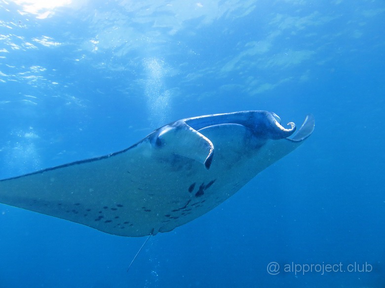
From the book "Bali Island", part 6 "Nusa Penida", episode 35.
8°47'44.10"S 115°31'33.40"E
Russian sailors who were pioneers of tropical waters called this relative of sharks as Sea devil. You can imagine what a superstitious horror they caused when this huge horned nightmare suddenly appears from the depths of the sea.. :-)
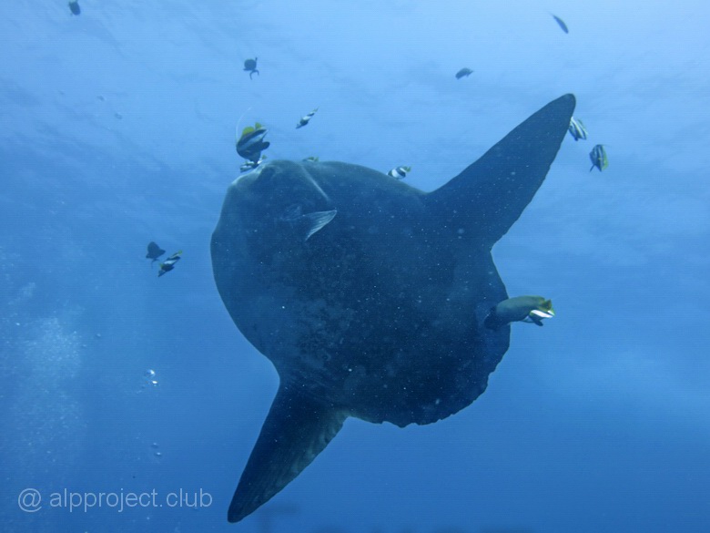
From the book "Bali Island", part 6 "Nusa Penida", episode 33.
8°41'0.60"S 115°28'57.70"E
There is North of the Nusa Penida island, Toyapakeh bay, where people arrive by boats and ferries from neighboring islands. You can see small island of Lembongan not far to the West. It is separated by not wide (up to 1km), but rather a deep strait, powerful cold currents come along it from the ocean to the Bali sea and sometimes they bring large inhabitants of the sea.
Eye to eye..
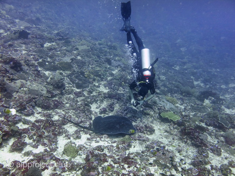
From the book "Bali Island", part 6 "Nusa Penida", episode 32.
8°40'30.00"S 115°30'52.80"E
Nusa Penida island is located closer to Lombok island then to Bali. But we will describe it in this section because almost all dive centers in Bali do arrange diving and snorkeling here, lovers of underwater world spend 20 minutes to come here by speedboats from the Padang Gulf.
Drift along a gentle underwater wall on the North of Nusa Penida island. Our georeference is arbitrary – you can come much East or West – the essence remains the same: all the dive will be along the flow. We had short stops during the dive for shooting the main attractions of this site – corals and fish scurrying around them..
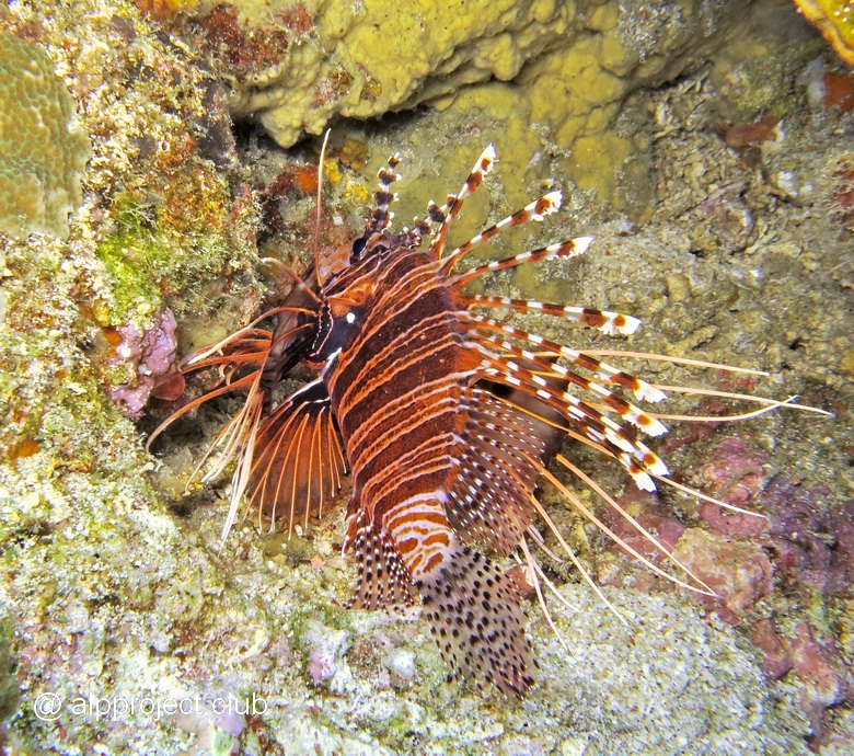
Lionfish
From the book "Bali Island", part 5 "East", episode 31.
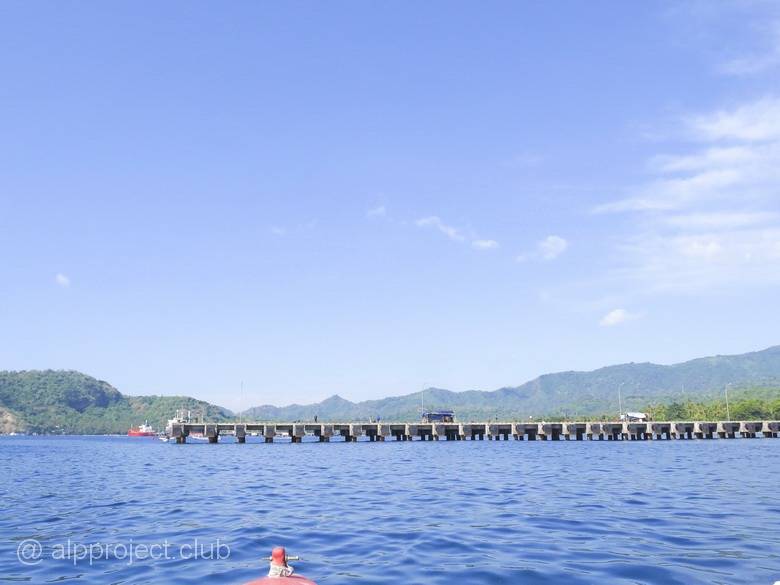
8°30'29.81"S 115°31'8.07"E
Tanah Ampo – sea port in the East of Bali, large cruise ships come here from Singapore and Australia. But we are interested by the pier, there are a lot of unique characters under it.
From the book "Bali Island", part 5 "East", episode 30.
8°31'30.58"S 115°34'34.98"E
Три крохотных островка рядом с Типиконгом, октябрь 2016 года. Годом раньше наши гиды встречали здесь рыбу-луну – мола-мола, но в этом году вода осенью была необычно тёплой, что гигантской рыбе не по нраву, она предпочитает прохладу.
Мы ныряли тут лишь один раз, весь дайв боролись с сильным течением. Не фотографировали, есть лишь видео. Персонажи в нём все известные, представлять никого не надо. Давайте понаблюдаем за ними: There are three tiny islands near Tepekong, October 2016. The year before our guides met here moon fish – Mola-Mola, but in this year the water was unusually warm that the giant fishes does not like, they prefer the coolness.
We dived here only once, the whole dive we were struggling with strong current. No photos, we got only video.All the characters in the movie are well known, it is not necessary to discribe anyone. Let's watch them:
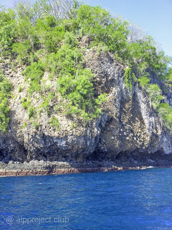
From the book "Bali Island", part 5 "East", episode 29.
8°31'54.62"S 115°35'13.26"E
Tepekong is the largest of the islands in the sea opposite the village of Candidasa. We'd dive near it three times – once in January and twice in October 2016. Probably it is the richest place of corals in this area. It is a rock of volcanic lava and reef limestone on the surface, it is covered with green bushes.
From the book "Bali Island", part 5 "East", episode 28.
8°30'34.82"S 115°36'52.87"E
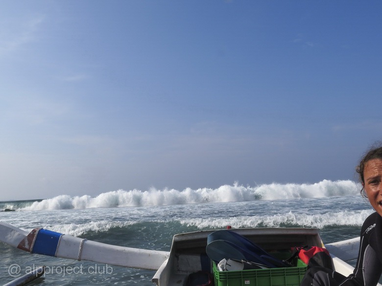
We are overcoming the line of the surf on the boat and going from our hotel Bali Santi Bungalows along the coast to the East.
From the book "Bali Island", part 5 "East", episode 27.
8°30'24.95"S 115°33'38.06"E
Candidasa (or Chandidasa which is closer to local pronunciation of this name) is a fishing village gradually turning into a resort because development of tourism. The main street of the village stretches for 2-3 kilometers along the sea and almost all hotels, shops and restaurants located near to it. The beaches near the hotels and villas are mostly stony, resting people swim in pools but snorklers and divers take boats to nearby small islands overgrown with coral reefs. We are divers, therefore, we almost had no time to survey the settlement and the surrounding area, except the evenings when we visited some vending restaurants. The rest of the time we admire the hotel Bali Santi Bungalows. It is inexpensive and quite nice - take a look:
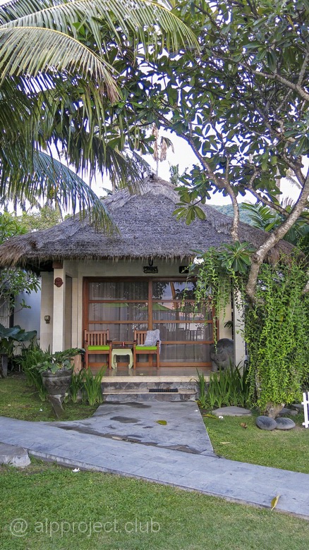
Bungalow
From the book "Bali Island", part 5 "East", episode 26.
8°31'40.44"S 115°30'52.39"E
300 meters to the North from the Blue lagoon along the coast.